Thursday, July 3, 2014

Airlie Beach to Cairnes

We arrived at Airlie Beach and were at  the Abell Marina for a few days where we met up with some of the boats from the rally to Indonesia. The we headed  to Cairnes to meet up with all the other boats  that also are going to Indonesia.These are pictures taken on the way to Cairnes. Also the movie"Australia" was filmed in the town of  Bowen which they were very proud off.
This is the town of Bowen. We wanted to show how wide the streets are, because they used to hustle cattle through the town.

Bowen  is also known for all 26 murals  that are displayed through out the town depicting the diverse history.


The lighthouse on Cape Upstart


The Abbot Coal Terminal.

Ships pull up to the jetty to load up with coal.

On our way we passed through this mud looking substance that went on for miles. We never did find out what it was.


It was pretty ugly.

Magnetic Island.

Magnetic Island , we did not stop there. We just sailed by.

Anchoring at Casement Bay right at sunset. It was just so beautiful.

And this is at sunrise. The reflection on the water was amazing.

Also sunrise at Casement Bay before we heaved  up anchor.

This rock is called the Bun and around the bend was this very nice village that we anchor  at Cape Upstart.

Cape Upstart.

Cape Upstart

As you can see the owl loves the sunsets as much as I do.


This is suppose to be the tropics, it sure didn't feel like it.

The Aboriginal center in Caines were we are now at the Marlin Marina. 

The wide streets of Bowen.

AA beautiful water park in Bowen, here the bucket is being filled and

The Abell Marina at Airlie Beach. This should have been the first pictures but my laptop has a mind of it's own.

Here the bucket is dumping the water on the slide. A really nice water park. The was part of the town of Bowen.

Wednesday, July 2, 2014

On the way to Airlie Beach.

We are now  at May 28th  which we heaved anchor from Pancake Creek to the Great Keppel Island got becalmed. Did an over night trip Went by Cape Capricorn  and the following day anchored at Leeks beach of Northern Great Keppel .Sorry I didn't take any pictures of that anchorage June 1st we heaved anchor and set sail for Roselyn Bay and went to the Keppel Bay Marina for one night. Very nice place.
Keppel Bay Marina At Roselyn  Bay

Keppel Bay Marina.

Left Roselyn Bay  and did another overnight to Mile Percy Island, this was June 4th.


Even our Owl is enjoying the sunset.
Another Hugh Yellow Patch.

June  5th we anchored at West Bay at Middle Percy Island.

White Cockatoos.

West Bay.


An a frame structure where for years yachtees have left something.

It's pretty fascinating to see all the things that the people have left.
 I didn't take any pictures after Middle Percy,and we arrived at Airle Beach on the 12th of June and I didn't take any pictures there either..

Tuesday, July 1, 2014

ON our way to Airlie Beach and still going.

Leaving on My 20th, beautiful day  with good winds but after a few hours of sailing  we had no wind. We motored and did several over nights. Next day we dropped anchor at Garry's anchorage at the Great Sandy Straits. Lovely place with a beautiful sunset. As I post the pictures they seem to want to place themselves not in order. I apologies, I don't seem to have control over that. Just enjoy.This covers from May 21st to May 28th.
First anchorage  "Garry's  Anchorage'

Awesome sunset.

The anchorage.

Great sunrise on the way to Pancake Creek which was to be our second anchorage.

This scene  brought us back great memories of the Canary Islands when Don use to help pull in the fishing nets. This is Pancake Creek.


This Cape Capricorn, we did not stop here.

Cape Capricorn lighthouse and fishing boats below.

This also part of Cape Capricorn called the Yellow Patch and it is very yellow.

Back to East Coast Marina after our trip to the States.


I have to go back a little bit as I have not posted pictures since the States' pictures. Any way we got back to
East Coat Marina on April  17th and started to get the boat ready to head out  on our next leg of our journey, heading towards Indonesia. But first our friends Bruce and Marcelle took us on a little trip by ferry boat to a place called Scrabrook. It was a lovely outing. We did more work and and a gathering with friends before leaving on May 20th.


After this beautiful sunset we headed back to Eat Coast Marina and back to work.
The day before we left East Coast Marina we were invited to some friends yacht for a farewell gathering. 

Bruce fixing our wind generator.

Saturday, June 28, 2014

AIRLIE BEACH TO CAIRNS, AU

June 19-28, 2014

The sailing distance from Airlie Beach to Cairns is about 315 nm.  Usually, we try to do this with day hops of 40 nm and avoid over night sailing.  If the winds are so light that we aren't able to accomplish this, I have no problem with over night sails in this part of the Great Barrier Ree system.  It's still wide enough to safely avoid the many islands and reefs.  Electronic charts and good GPS make it relatively easy.

We departed Airlie Beach on 19 June 2014 at 0830 hrs enroute to Cairns.  Our first stop was at Bowen (20-01.0' S x 148-15' E)  which is 35 nm north of Airlie.  We were able to get a pile mooring for two days and went out exploring the small town of 10,600 people.  Not a whole lot there but is most famous a the movie set for "Australia" which starred Nicole Kidman and Hugh Jackman.  We haven't seen the movie but have it on our list.  Bowen was a cattle town and has very wide streets where the herds were driven into pens and auctioned.  I think this is shown in the movie.  Additionally, it supports seafood, mining and  horticulture.  There was a great restaurant serving meat pies and pastries.  The other unique feature of the town is the 26 hand painted murals on various walls depicting the diverse history of Bowen from the town's early settlement to present day.  There was a good historical museum with lots of artifacts and memorabilia from the area.  Other than that, nothing outstanding.

Bowen was hosting an international  power boat show on Saturday June 21st: these are the "cigar boats that go 200 km per hr and make an ungodly sound that is deafening.  We got out of there at 0630 hrs before the event started and set sail for Cape Upstart (19-42.6' N x 147-45.1' E) which is 40 nm further North.  This turned out to be a very pretty anchorage with mountains and a few houses (mostly rustic type campsites for fishermen).  It was a peaceful setting.  Many of these anchorages with mountains generate "bullets" of wind which are unsettling;  not so at Cape Upstart.

On June 22nd, we weighed anchor at 0715 hrs and got underway for Magnetic Island: 30 nm North.  the wind was light and fickle from the SE at less than 10 kts and eventually died out.  By 1300 hrs there was no wind but a SE'ly swell so I started the engine and and motored along until 1524 hrs when the wind came back up and we set sail once again.  Our progress had been so slow that we decided to over-night it with what wind we had and passed Magnetic Is by for Great Palm Is about 35 nm further NW.  During this time of light SE'ly winds we used mostly the head sail since the winds were just off either the Port or STbd. Qtr.  Unless we ran out the mainsail on on side and the jib on the other (Wing and Wing) the mainsail would blanket the jib and rob it of the little wind there was.  Additionally, with very light winds and a good swell running, the swell rolls the wind out of the mainsail and causes it to slat back and forth.  This is hard on the sail and my nerves!  Decent wind came up after we cleared the wind shadow of Magnetic Is and we sailed along and dropped anchor in Casement Bay, Great Palm Is (18-44.2' S x 146-33.8' E) at 0930 hrs on June 23rd.  This island is an aboriginal settlement.  We are starting to see several of these remote areas that were "given" to the aborigines to get them out of the way.  Basically, the same thing we have done to the Native Americans.  They have the same alcohol, drug and crime problems that are encountered in our own Native Americans: a way of life, religion and raison d'etre have been destroyed.

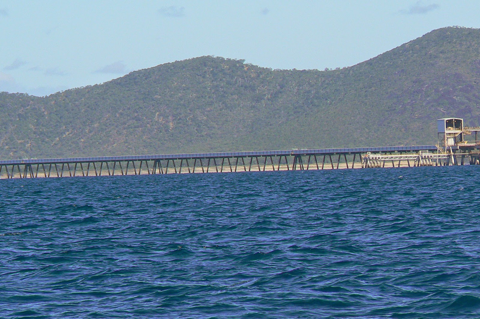
We haven't had time to launch the dinghy and explore these islands and villages so we anchor, hope for wind and continue on.  On June 24th, we weighed anchor at 0800 hrs and set sail Lucinda and Hinchinbrook Is.: 30 nm to the NW.   The port of Lucinda has one of the world's longest jetties jutting out over 3 miles with a sugar loading facility on its end.  This is sugar country as  ismuch of the Queensland coast.  It's shallow with many shoals.  The jetty solves this problem for ships but for a yacht entering the southern end, one has to wait for a tide complementary to the LWS (Low Water Springs) of 4'ft.  In our case, we draw 6' so we need a tide of at least 2' plus any swell running.  I chose to wait on another 4' before entering so we lay ahull for several hours off the sugar jetty and waited.

We started into Port Lucinda at 1615 hrs and entered Hinchinbrook Channel 1700 hrs.  We had 8 nm to go to our chosen anchorage at Reis-Haycock Is (18-28.1' S x 146-13.2' E).  With a rising tide and very strong current we zipped along at 8 kts and anchored at 1800 hrs.  The Hinchinbrook Channel is spectacularly beautiful.  It has the mountain range of the mainland to the West and its own mountain range on the East.  Hinchinbrook is a National Park and World Heritage Site.  There are few places to land a dinghy but many creeks to anchor in and enjoy the absolute silence and beauty of pristine wilderness.  There are mosquitoes so burning coils and 12V Zappers are helpful.  We believe that Gary's Anchorage in the Great Sandy Straits and Hinchinbrook Is. are the two most memorable and beautiful places we have see so far in Australia.  Most of the Great Barrier Reef consists of scrub land and mountains with a smattering of beaches: not my idea of South Pacific Tropical Paradise.  We've seen the best and the GBR is second rate in landscape but pristine in reefs.

The next stop after Hinchinbrook Is was Dunk Is. (17-56' S x 146-08.0' E) about 35 nm NW.  Once again we were given light winds and then becalmed.  We had to motor several hours to make the anchorage before nightfall.  We dropped anchor at 1500 hrs on June 25th.  Dunk Is was once a gathering point for many artisans and a rendezvous point for yachts travelling North.  There was a small resort and walking trails.  In 2011, a cyclone hit the island dead-on and destroyed the resort and artists gallery.  Today, there is only the jetty remaining but the future will bring renewed development.  It's a pretty island and we went over to the beach for "sundowners" with a few cruising friends from "Gypsy Rover".

The following morning we weighed anchor at 0730 and proceeded to sail to Mourilyan Harbor (17-36.2' S x 146-07.4' E) which was only 20 nm away.  We had a beautiful wind out of the SW at 15 kts and smooth seas.  It was a very pleasant sail but too short!  Ah!! the inherent ingratitude of mankind!!

On June 26th at 0730 hrs we weighed anchor for Fitzroy Is. (16-55.7' S x 145-59.3' E) about 45 nm distant.  Another good day of sailing with SE'ly winds 15-20 kts.   We were able to sail along under headsail at 5.5 kts for most of the way.  We dropped anchor at 1615 hrs on the Northern side of Fitzroy Is.  It's an anchorage that is swell prone and rolly.  In a developed Trade Wind it would be marginal at best.

Fitzroy Is is only 15 nm from Cairns.  Our original plan was to anchor in Mission Bay, which is another aboriginal settlement, for the night and make Cairns the following day.  When we got to Mission Bay, there was no wind and the place looked uninviting so we decided to continue on to Marlin Marina in Cairns.  This will be the rendezvous point for the Sail2Indonesia Rally.  Our first meeting will be on Tuesday July 1st.  We will be here until July 8th and then depart for Thursday Is:  400 nm further North for the check out to Saumlaki, Indonesia:  600 nm from Thursday Is.

First impressions of Cairns are that is it a beautiful place with a significant SE Asian population.  It has everything a cruiser or tourist could imagine or want.  Beautiful broad maritime walkways and parks.  Fresh fruit and vegetable farmer's markets along with every imaginable ethnic restaurant.  It is a bustling center for helicopter flights to the GBR and resort islands, cruise boats, para-sailing and every other kind of water sport.  The only thing it lacks are beaches:  mud flats out to 1/2 mile at low tide, however, to the North or South one finds beautiful beaches.

This will be the last great place for "grubbing-up" for the trip to Indonesia.  I believe we will have "duty free" at Thursday Is.


Monday, June 16, 2014

GREAT KEPPEL ISLAND TO AIRLIE BEACH

June 1-17, 2014

The northern anchorage at Leeks Beach on Great Keppel Is (23-09.9' S x 150-56.7' E) turned out to be quite rolly so after  a few days we decided to weigh anchor and move over to Rosslyn Bay marina which is about 10nm from the anchorage.  It turned out to be a good choice and we were able to do some shopping in the small town of Yeppoon which is a bus or taxi ride a few miles north of the marina.  Rosslyn Bay has become the epicenter of tourist activity for the Keppel Bay islands.  We stayed only one day but grubbed up for the trip north.

June 2, 2014
Departed the marina for Middle Percy Is (21-39.2' S x 150-14.6' E) which is 110 nm to the north.  As with a good part of the trip from Brisbane, we had light wind and no wind.  We took  in all sails and sat becalmed for many hours waiting for a puff here or there: set sail - drop sail - set sail again.  It wasn't until late in the evening of  June 3rd after rounding High Peak Is Lt. Ho (21.53.3' S x 150-34.4' E) that we, finally, got some wind from the SE.  This carried us to Middle Percy Is and we dropped anchor in West Bay of Middle Percy at 0700 hrs on June 4th.  With all the light winds, West Bay had no developed swell so it was enjoyable being at anchor there.  In  developed Trade Winds, the rolling can be abominable, however, such is the beauty and fame of West Bay that it is seen as an obligatory stop for most cruisers heading north.  Ashore, there is a large 'A' frame shelter where cruisers can can congregate and exchange stories of their travels.  In this 'A' frame, cruisers have been hanging their their names and mementos for over sixty years.  We left an old Pentax 1000 camera on a strap hanging there.  Phyllis will have some pictures when she can post again.  Middle Percy wa grazed by sheep for many decades.  One  can see that some of the families lived there in isolation for over forty years.  Today, there are no longer any sheep being grazed but the present lessees have twenty-five colonies of bees and sell honey and lime juice out of the "A' frame on an honor system with an "honesty box" in the building.  The honey is delicious! The lime juice strong!

On June 6th at 0712 hrs, we weighed anchor and set sail for Scawfell Island (20-51.6' S x 149-36.0' E) which is about 60 nm to the NW of Middle Percy Is.  We had a good SE'ly wind at 15-20 kts and managed to make the 60 nm in twelve hours under jib only. Dropped anchor in Refuge Bay, Scawfell Is at 1900 hrs.  As the Trade Winds were becoming more developed, there are "bullets" of wind that descend down the mountainous terrain.  I believe these are katabatic winds that develop as the SE Trade Wind hits the windward side of the mountains and then rushes over the top and spills down the gullies or valleys.  They pack quite a whollop and you can here them coming like a freight train.

On June 7th at 0830 hrs we weighed anchor from Scawfell Is to Airlie Beach (20-16.0' S x 148-42.6' E) via Shaw Island (20-30.1' S x 149-03.1' E).  The total distance is about 60 nm but we decided to anchor at Shaw Is for the evening and wait out a "strong wind" warning from the Aussie Met Service. High Pressure systems that develop in the "bight" of the southern part of Australia form a ridge of high pressure over the Queensland coast over which the Trade Winds develop and blow.  The stronger the High Pressure system, the stronger the Trade Winds: 25-30 kts is not unusual.  If, perchance, a Low Pressure system develops in the western Coral Sea (around Papua, New Guinea), the Trade Winds will become "enhanced" and blow 35+ kts with stronger gusts.  This is a good time to seek a safe anchorage or marina.  That is exactly what happened while we were at SE tip of the Shaw Is anchorage.  From June 7th to June 12th we sat out the strongest winds we have experienced to date.  Gusts to 50 kts hit the boat in waves and during one squall I had to go out and tether the wind generator and solar panels lest they become unshipped and blown away!  I had 190' of chain out in 30' of water depth with a 30' nylon snubber to take the shock loading on the chain and I was amazed that we held fast during those four days.  It was an anxious time and unnerving to sit through that howling wind.  Squall after rain squall hit the boat for four days.  Finally, on June 12th, we weighed anchor at 0918 hrs and set sail for Abell Point Marina at Airlie Beach (20-16.0' S x 148-42.6' E) about 30 nm from Shaw Is.  Still had a good SE'ly at 20-25 kts and 7' seas but we were running downwind with a favorable current so the sailing was pleasant.  We were all fast at  Airlie Beach at 1430 hrs.

Abell Point Marina at Airlie Beach was one of the designated muster points for the SAil2Indonesia Rally.  Due to bad weather in Opua, NZ which lasted for three weeks, the Airlie Beach muster point was changed to Cairns which is another 315 nm north.  We will be setting sail from Airlie Beach to Cairns on Thursday June 19th.  We have to muster at Cairns by July 1st to take care of all the bureaucratic formalities associated with the Indonesian government.

Sailing up the Queensland Coast is made safe with Wx reports from dedicated Coast Guard stations and Volunteer Marine Rescue (VMR's) organizations which are stationed all along the coast.  A cruiser can log in with them and they transfer you from one organization to another as you move out of VHF radio coverage from one area to another.  These VMR's are dedicated people that will help in anyway possible.  It is a far more efficient system that anything we have experienced so far.

Abell Point Marina has exceeded all expectations in terms of friendliness, cut-rate prices and berthing.  They were planning on the whole fleet of Sail2Indonesa being here but only 8 boats showed up - all the rest going to Cairns.  They have given us super yacht berths and hosted a night of free drinks at the Barcelona Tapas Bar.  It doesn't get any better than that!

As we move north, the Trade Winds will become more established and stronger.  Thursday Is, at the northern end of our Australian trip up through the Great Barrier Reef, has some of the strongest Trade Winds in the world!  That will be our check out point for Saumlaki, Indonesia: 640 nm from Thursday Is.  This should happen on July 23rd.